
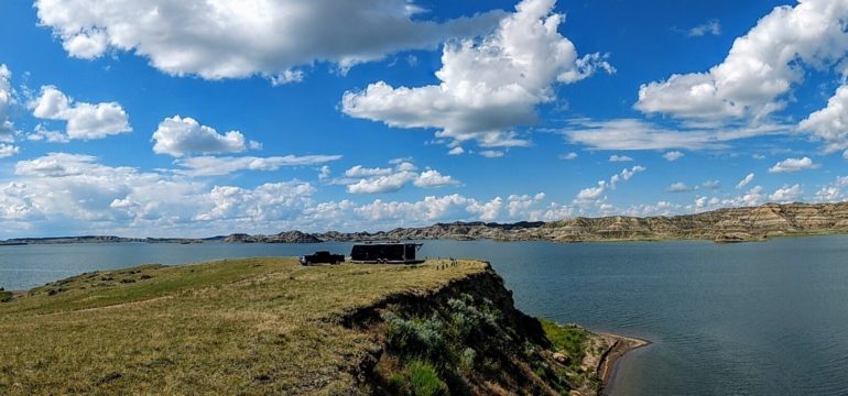
Fort Peck Lake is a massive body of water in eastern Montana, the creation of a dam built along the Missouri River during the 1930s by the Army Corps of Engineers.
As a result, it created lots and lots of recreational shore line.
Most of that shore is inaccessible by vehicle. Yet still, there’s a lot of campgrounds and dispersed camping to be had.
Where to Camp for Free on Fort Peck Lake
- Bone Trail Campground – (47.6763, -107.2477) located on the north side of the Fort Peck Lake, just south of Glasgow, Montana. This scenic area offers 10 primitive campsites with interpretive signage, picnic tables and campfire rings. Amenities include a boat ramp, a vault toilet and a shade shelter.
- Crooked Creek Campground – (47.4320, -107.9372) This recreational area has a boat ramp with a dock, 20 camping sites without electricity, a picnic shelter, swimming beach, and potable water is accessible to fill tanks. Campsites have picnic tables and fire rings. There is a marina located nearby that offers concessions, boat storage, and cabins for rent.
- Devil’s Creek Campground – (47.6169, -107.6534) located on the south side of Fort Peck Lake. Enjoy wildlife viewing, interpretive signage, fishing and boating at this primitive camping area. Amenities include a shade shelter, picnic tables, campfire rings, a vault toilet and a boat ramp.
- Duck Creek Campground – (47.9884, -106.5245) This primitive camping area has 15 designated campsites with picnic tables and fire rings. Amenities include vault toilets and a boat ramp. Enjoy a location with easy boating access. Duck Creek Campground is also just a few miles away from where you can buy gas, bait and fishing licenses.
- Flat Lake Campground – (48.0189, -106.3673) offers camping, boat ramp and dock, picnic shelter and tables, vault toilets, and established firepits. Also adjacent to a stocked fishing pond.
- Floodplain Recreation Area – (48.015675, -106.437185) – A small number of campsites for RVs here with boat ramp and picnic tables.
- Fourchette Creek Campground – (47.6707, -107.6640) located on the north side of Fort Peck Lake, south of Malta, Montana. Open all year, interpretive signage, enjoy boating, fishing and wildlife viewing at this primitive campground. Amenities include picnic tables, fire rings, vault toilets, shade shelter and a boat ramp.
- McGuire Creek Campground – (47.6111, -106.2343) located on the section of Fort Peck Lake known as the Big Dry Arm. Open all year, this primitive camping area has 12 designated campsites with picnic tables and campfire rings. Amenities include a vault toilet and small boat launching from the shoreline, no boat ramp. Enjoy fishing and wildlife viewing.
- Nelson Creek Campground – (47.5626, -106.2239) located on the section of Fort Peck Lake known as the Big Dry Arm. Open all year, this primitive camping area has 25 designated campsites with picnic tables and fire rings. Amenities include vault toilets and a boat ramp. Enjoy boating, fishing, wildlife viewing and beautiful scenery.
- Roundhouse Point Campgound – (48.024154, -106.440997) – A few campsites large enough to accommodate RVs sits on a point that juts out into the Missouri River, just below the dam.
- Slippery Ann Campground – (47.6164, -108.5801) Each fall (September and October), hundreds of elk congregate in the Slippery Ann Wildlife Viewing Area, creating a spectacle not to be missed at the Charles M. Russell National Wildlife Refuge. Hundreds of elk congregate here during the fall rut offering spectacular wildlife viewing opportunities. Large herds are visible around dawn and dusk displaying typical behavior of the rutting season. The Slippery Ann Wildlife Viewing Area is along an excellent 20-mile long self-guided tour which may be accessed from two points along Highway 191 on the west side of the Refuge and takes about 2 hours to complete. The tour route follows an all-weather gravel road that parallels the Missouri River before climbing out onto upland prairie and rolling rangeland. This tour will take you near Lewis and Clark’s May 22, 1805, campsite as well as the wildlife viewing area. Make sure you carry plenty of water with you on the refuge there is no drinking water available along the route.
- The Pines Campground – (47.8348, -106.6308) This primitive campground has interpretive signage, several designated campsites with picnic tables, picnic shelters, playground and campfire rings. Amenities include a boat ramp, vault toilets, a fish cleaning station and a shade shelter. Enjoy boating, fishing and wildlife viewing at this scenic location.
- West End Recreation Area – (47.997993, -106.480372) – Not the same as, “West End Campground” which is a pay-campground. West End Recreation Area has campsites and picnic tables.
Leave a Reply